


West Wimmera Shire Council
Flood information for the West Wimmera Shire Council, encompassing local flood guides and a Municipal Flood Emergency Plan.
West Wimmera Shire Council Flood History
West Wimmera Shire Council has towns that are subject to stormwater and riverine flooding. Towns that are prone to stormwater flooding include Apsley and Edenhope.
Flood events within West Wimmera have been infrequent over the last decade. The most recent flood event was recorded in 2016.
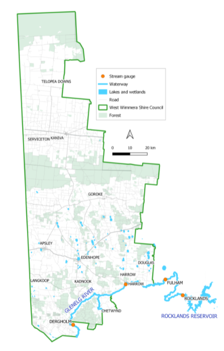
The Shire has three major waterways that impact various townships, localities and the rural areas. They are the Glenelg River (including Salt Creek), The Chetwynd River and the Koijak Creek.
These systems flow in or near to towns within the Municipality. Lake Wallace at Edenhope is the largest body of water in the Shire.
Predominantly two townships are impacted within the Shire from flooding events - Apsley and Harrow. The township of Harrow has experienced two large flood events within the last 10 years, with the flood in 2010 being the largest recently recorded event.
Apsley has had numerous smaller events, predominately due to rainfall and water not draining away as quick as other areas. Within the West Wimmera Shire rural flooding can be significant, other townships do experience some flooding during large flood events within the region.
Harrow Local Flood Guide
Are you at risk of flooding?
Harrow is located on the Glenelg River with several small tributaries in close proximity, the most significant of these is Salt Creek, flowing into the Glenelg River immediately upstream of Harrow.
Harrow has been subject to extensive and frequent riverine flooding from the Glenelg River. The Glenelg River begins in the Grampians National Park, and flows into Rocklands Reservoir.
The Rocklands Reservoir is a significant storage that has significantly altered the flow regime of the Glenelg River, 75 km upstream of Harrow. The area surrounding Harrow is agricultural land drained by the Glenelg River. Harrow generally floods due to heavy rainfall upstream.
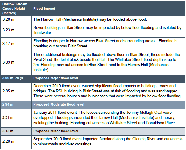
When flooding occurs in Harrow, homes, businesses, and buildings in Blair Street are most at risk. Floodwater rises very quickly in Harrow, houses can be impacted by flooding within 24 after heavy rainfall. Floodwater can remain high for twodays before receding.
About Flood Guides
Communities can use local flood guides to identify and better understand their local flood risk. They include information about: flood history, how to prepare & respond to floods and who to contact.
Contact Information


Local VICSES Units
- Edenhope Unit:
- 26 Mollison Street,
- Edenhope, Victoria 3318
- Goroke Unit:
- 4 Barrack Street,
- Goroke, Victoria, 3412
- Kaniva Unit:
79 Commercial Street,
Kaniva, Victoria, 3419