Hobsons Bay City Council

Flood information for the Hobsons Bay City Council, encompassing local flood guides and a Municipal Flood Emergency Plan.

On this page:


Hobsons Bay municipal map.
  Hobsons Bay municipal map.

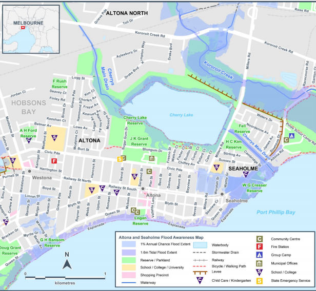
Large severe floods within the Municipality generally occur as a result of a moist warm airflow from northern Australia bringing moderate to heavy rainfall over a period of 12 hours or more following a prolonged period of general rainfall. 

The period of general rainfall “wets up” the catchments and (partially) fills both the on-stream dams and the natural floodplain storage. These combine to increase the runoff generated during the subsequent period of heavy rainfall.

Short duration, high intensity rainfall (usually associated with thunderstorms) can also cause localised flooding within the municipality along overland flow paths when the local urban drainage system surcharges. 

Such events, which are mainly confined to the summer months, do not generally create widespread flooding since they only last for a short time and affect limited areas.  Flooding from these storms occur with little warning and localised damage can be severe.


Are you at risk of flood?


 Altona and Seaholme flood guide area
  Click to enlarge.

Altona and Seaholme are coastal suburbs on relatively flat terrain. This makes the stretch of land near the bay susceptible to flooding during high intensity rain or storm events.

When a storm occurs during a very high tide and southerly winds, sea water can come over the flood wall next to the beach. This is called ‘storm surge’ flooding and results in Beach Street and The Esplanade flooding frequently; especially near Sargood and Bayview street.

It can also lead to potential flooding of underground car parks. Flash flooding can also be an issue for the Altona/ Seaholme area, where a high amount of rain occurs and can’t drain away fast enough. This can especially occur during high tides where the drains can struggle with the push of water back from the ocean combining with the flat terrain of Altona and Seaholme.

Areas that can be affected include:

  • McIntyre Drive

  • Civic Parade all the way to McIntyre Drive

  • The area between Civic Parade and the railway line from Seves Street

  • Areas south of Linnet Street, either side of Mulga/ Manning Street. Finally, the Altona and Seaholme area is also at risk from flooding during longer rain events where Laverton Creek, Cherry Lake and Kororoit Creek could flood.

  • Green areas and levees in the area provide some protection for properties, but the Altona/ Racecourse road and sections of the Werribee railway line may be flooded if the Kororoit Creek overflows.

The map to the right shows the impact of a 1% flood in the Altona/ Seaholme area. 

About Flood Guides

Communities can use local flood guides to identify and better understand their local flood risk. They include information about:
flood history, how to prepare & respond to floods and who to contact.

Contact Information

For information on flood warnings, see the VicEmergency website.
Your local Catchment Management Authority: Melbourne Water.

Local VICSES Unit

Hobsons Bay VICSES Unit:
149 Civic Parade,
Altona VIC, 3018

Municipal Flood Emergency Plan (MFEP)

Municipalities can use Municipal Flood Emergency Plans to prepare, respond and recover from flood and storm events.
Hobsons Bay Storm and Flood  Emergency Plan - Updated Oct 2020